The consequences of nitrate (N) loading on water resources and agricultural yields are important and much debated. Recent legislation allows farmers to increase N‐application considering only economic benefits. This poses a risk of an increased N‐load to the surface- and groundwater.
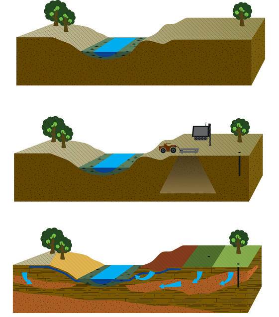
To counteract this, detailed regulation is scheduled to reduce N-emissions from 2019, allowing farmers to target measures for the largest effect. The current N-reduction maps, based on approx. 15 km2 (ID15) areas, are too large for effective management. Our Vision is that more effective targeting can be achieved using innovative geophysical mapping in combination with hydrogeological, and geochemical modeling. This higher resolution will improve the prediction of nitrate transport in the open landscape at field scale (a few hectares). Furthermore, it will lead to a transparent, data-driven decision support tool that will be cost effective on the national scale. Such improved management can lead to targeted regulation and more efficient fertilizer utilization benefiting both the agricultural sector and the environment. The concept is illustrated in Figure 1.
rOPEN is an interdisciplinary project of coordinated scientific activities with the objective to produce:
- Ground based geophysical instruments for high resolution mapping of shallow geology and location of tile drains
- Software to combine geophysical and geological data to estimate the essential subsurface structures
- A tool for data fusion enabling semi-automatic creation of coupled root zone and groundwater models with geophysical, hydrological and geochemical data
- A calculation of the economic impact of suggested measures, positive and negative, for the individual farmers and on the national scale as a whole
- In a few selected agricultural catchments the instruments and tools will be used to determine:
- N-retention, -leaching, -fate and -transport with hectare scale resolution.
- Where mitigation measures can be located best in the landscape to balance environmental impacts and economic benefits.
- Evaluate the potential for applying the developed geophysical methods in related applications such as mapping of contaminated sites
By combining the expertise and the scientific activities, rOPEN will meet the societal desire for mapping of N-retention at field scale and we will develop the necessary tools. The outcome of the project will therefore benefit:
- Individual farmers, without the detailed knowledge of N-retention, they are expected to meet more general regulations on N application due to limited knowledge of the N-retention at field scale. These farmers are also likely to benefit from the detailed mapping of their fields for improved management.
- Society, benefitting from thousands of jobs and large export opportunities from a financially healthy agricultural industry in balance with the natural environment.
- Research institutions, strengthening their international reputation within the important scientific areas of geophysics, hydrology, geology, geochemistry, microbiology, agricultural-related land management, and the links between applied N and the N loss.
- Citizens (human health) through protection of surface and groundwater resources from N pollution, which is of economical and recreational interest.