Hydrological and hydrogeological investigations
During the project, hydrological and hydrogeological data will be collected within both field areas. The hydrological measurements will consist of continuous monitoring of stream stages and monthly stream discharge measurements, respectively, at 4-5 gauging stations within the two catchments. These data will be collected during most of the project period. The stage discharge data will be used to develop rating curves which will provide a base for estimating continuous stream discharge time series. Stream discharge data are essential for groundwater flow model calibration. Furthermore, these data provide important information on how the surface and groundwater system respond to rainfall. For instance, stream discharge will increase quickly after rainfall if the system is dominated by tile drain flow and/or over-bank flow. This also means that during periods with limited rainfall and/or high evapotranspiration, the streamflow will most likely be limited or the streams may go dry.
The hydrogeological measurements will be made directly in the boreholes drilled as a part of the geochemical data collection. These measurements will provide the researchers with information on the hydrogeological properties of the subsurface. More precisely, it will be used to estimate the hydraulic conductivity, and thereby assist to give an estimate of the groundwater flow velocity in the aquifer systems.
Geochemical investigations
We conceptualize the distribution of groundwater flow paths and the fate of nitrate along them and quantify the rate of nitrate dissipation by synthesizing geophysical, geochemical, and hydrological datasets. Through borehole drilling, we make direct observations of the subsurface environments. Based on the geophysical measurements, we select drilling locations that may reveal the representative hydro-geochemical processes of nitrate evolution of the subsurface. In this WP, we compare the physical and geochemical properties of the sediment with the geophysical data, verify our hypotheses of groundwater flow paths and nitrate evolution, and quantify the rate of nitrate dissipation. This work will provide essential datasets for a better simulation of nitrate transport and fate for integrated modelling.
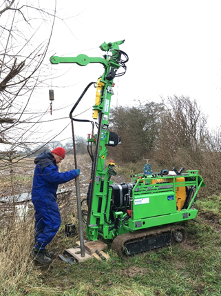
Three rounds of drilling campaigns will be carried out. In the first round, we will characterize the basic physical, lithological, and geochemical properties of the sediment and define the structures of redox interfaces (by sediment colors) and groundwater systems. To achieve these goals, we will use a Geoprobe, which allows collecting intact sediment samples. In the second round, we will collect depth-discrete (multilevel) groundwater samples from drilling boreholes using an Ellog driller. We will analyze the groundwater samples, focusing on the species that are essential to investigate the evolution of nitrate in the subsurface (e.g., nitrate, nitrite, dissolved organic carbon, dissolved oxygen, iron). Detailed snap shots of the spatial patterns of nitrate in groundwater will be captured through this campaign. In the final round, we will collect sediment samples, using the Geoprobe, for quantification of nitrate dissipation rates via microbial culture experiments and for geochemistry analysis (e.g., pyrite content). We will also quantify the age of groundwater using 3H/3He.
