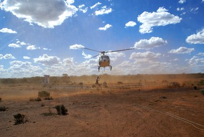
 The SkyTEM system is a helicopter-borne TEM system designed for hydrogeophysical and environmental investigations. The SkyTEM system is the result of decades of dedicated research and development by the HGG group.
Today, the spin off company SkyTEM aps. is a fully commercial company flying SkyTEM surveys worldwide, with the processing and inversion software (Aarhus Workbench) being sold separately by Aarhus Geosoftware.
Despite the commercialization of the systems, research and development continues in top gear.
From the start, a very high quality of data was demanded for the SkyTEM system as this is essential in hydrogeophysical mapping. Together with the ongoing development of the SkyTEM system, research in high precision processing and inversion algorithms continues. The delay between research results and implementing it in the software (Aarhus Workbench, AarhusInv) is often very short.
In larger hydrogeological research projects, a SkyTEM survey covering the area will reveal the geological setting in detail. This information is essential, for example, as an input to geological and hydrological models.
Present research topics for the SkyTEM system are:
Higher transmitter moment for larger penetration depths (250-500m). There is always a demand for larger penetration depths.
