The SkyTEM Antarctica project aimed to map subsurface resistivity usi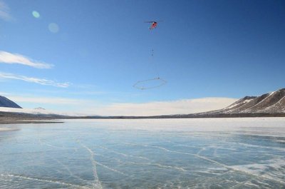 ng the Time Domain Electromagnetic (TEM) method, which offers a non-invasive and efficient way to determine the subsurface distribution of water salinity, hydrogeologic connectivity, buried geomorphic surfaces, including buried ice and the extent of permafrost.
The newly developed transient electromagnetic system is ideal for use in Antarctica for distinguishing between high resistivity (glacier ice and bedrock, permafrost) and low resistivity materials (geologic materials that are clay-rich and/or saturated by salty water) to a depth of 300 m or greater.
The SkyTEM system (developed at Aarhus University) is mounted under a helicopter for an extensive geophysical survey of the McMurdo (MCM) region to generate three-dimensional maps of subsurface resistivity structure over inaccessible terrain. Despite the high potential for TEM to address important science questions in geobiology and the earth sciences, Airborne EM methods has to date not been deployed in the polar regions, and hence the study will be a proof-of-concept for the applicability of the TEM method for mapping the conductivity, depth of water and permafrost in Antarctic subglacial and subsurface environments.
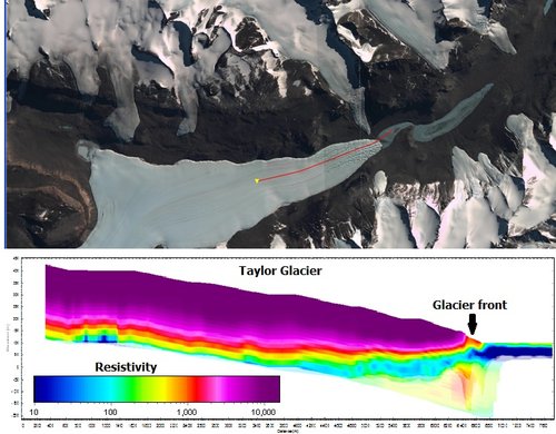
The Taylor Glacier is clearly seen as a an area with a high resistivitve as compared to the meltwater flowing beneath the glacier.
Auken E., Mikucki J., Sørensen K. I., Schamper C., Sab G.-A., and Tulaczyk S., 2012, First airborne transient EM survey in Antarctica: mapping of saline ground water system. Near Surface annual meeting – Remote Sensing Workshop (Paris, 3-5 September 2012).
Sab G.-A., August 2012, Data processing of an Airborne Electromagnetic survey in Antartica. Master thesis.
Danish newspapers and online journals:
Ingeniøren - Grundvand i Antarktis kortlagt med helikopterbåret dansk system
Århus Stiftidende - Århusiansk opfindelse revolutionerer Arktis forskning
Aktuel Naturvidenskab - Dansk teknologi kortlægger Antarktis undergrund
Aarhus University newsletter - SkyTEM trumferer i Antarktis
English newspapers and online journals:
The Antartic Sun - Scratching beneath the surface
National Science Foundation - First-ever use of airborne resistivity system in Antarctica allows researchers to look beneath surface in untapped territories
