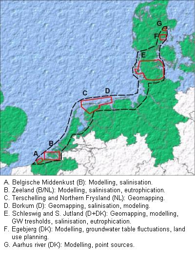
 The Cliwat project focuses on “determining the effects of climate change on groundwater systems and through this, on surface water and water supply”. Some other targets of the project are the assessments of forced leaching from point sources and agricultural sources into the hydrological system to rivers and lakes.
The project covers a large area, including Denmark, Netherlands, Germany and Belgium, all split up in different pilot areas (see Figure). The HGG is involved in pilot areas B, C, E, F and G, for IP-DC, MRS, and airborne EM measurements.
IP/DC
The IP/DC surveys are performed on landfill areas; they aim at characterizing the waste body in the investigated landfills and, to some degree, the outflow of polluted plumes. We also aim hereby at providing high data quality as input for hydrogeological models.
MRS studies
The main outcome of the MRS studies (Tønder, Terschelling, Friesland) is the aquifer characterization, in terms of geometry and hydrogeological properties.
Airborne EM
The Airborne EM method is performed for mapping the freshwater/saltwater boundary in coastal areas (Tønder, Terschelling, Friesland) with a high accuracy, together with clay-rich layers governing the water flow. The method is used as a very efficient tool to map the fresh water resources.
The official Cliwat website
http://cliwat.eu/