The survey will start on June 14th and end on June 29th. The main survey area will be Norsminde, and there will be also one small area in Fynen (Lillebæk) which can be made in one or two flights. Since Norsminde survey area is not too large (around 130 km2), we plan to make flight lines separated by a smaller spacing than usual to get a good lateral resolution.
For Norsminde area, a total amount of 2584 km is expected for a spacing of 50 m (flight lines are divided into two sets with a spacing of 100 m, as it is eventually planned to do the two sets in two times), and 1724 km for a spacing of 75 m (see Fig. 1 and 2). It is expected that the speed of the helicopter would be larger than the classical speed of 45km/h for Danish Skytem survey, slightly above 100km/h. However, the speed has to be confirmed after the next field tests of the new mini-Skytem loop designed to give a better resolution of the near-surface geology.
For Lillebæk, the survey area is only 15 km2, so a line spacing of 50 m can be reasonably scheduled. A total length of 302 km is expected for this area (cf. Fig. 3)
Esben Dalgaard, PhD student from AU, plans to do MRS measurements to determine the hydraulic parameters.
- First measurements with the new electronic acquisition system have shown that the system response is very stable, and that it should be easily removed from the data to get the earth response.
- Field tests during the week of May 23th:
- Aerodynamic tests of the new frame of the mini-Skytem loop
- Tests of the emitting and receiving systems with the old frame, and also with the new one. These will give some first data which will help us to prepare the interpretation software (WorkBench) to handle the data of the new system.
- Determination of the landing sites for both Northminde and Fynen. Due to the proximity of the survey area from the national test site in Aarhus, no local ground TEM measurements have to be made to calibrate the new system, and just a reference location has to be defined to check the repeatability and detect an eventual drift of the data during the survey.
- The measurement of the source waveform will be made just before the beginning of the survey, for calibration purposes.
Processing of the data will start at the beginning of the survey since it can be collected after each end of day. First interpretation results are expected to be available in the middle of the summer. Deeper processing and interpretation have to be made to get information from the very early times that have never been measured and so processed before. These early times will help us to refine the geological model we will obtain after the first interpretation.
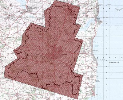
Figure 1: Planned Norsminde flight lines with a spacing of 50 m
(130 km2 and a total 2584 km). Thick black line: catchment area. Red and black parallel lines: the two sets of flight lines with a spacing of 100 m.
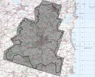
Figure 2: Planned Norsminde flight lines with a spacing of 75 m
(130 km2 and a total 1724 km). Thick black line: catchment area.
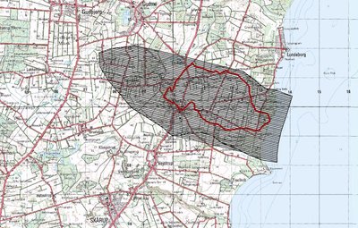
Figure 3: Planned Lillebæk flight lines with a spacing of 50 m
(15 km2 and a total of 302 km). In red: catchment area.
